
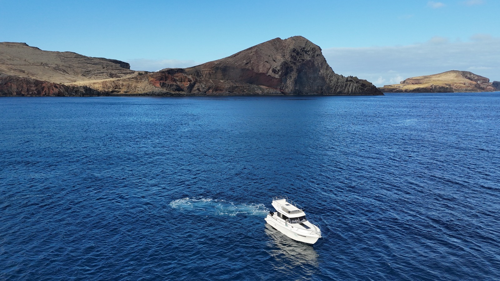
The easternmost point of Madeira Island presents a striking contrast to the lush, green landscapes that define the rest of the archipelago. Ponta de São Lourenço is a rugged, semi-arid peninsula stretching approximately nine kilometres into the Atlantic Ocean [1]. Characterised by dramatic volcanic cliffs, sparse vegetation, and relentless exposure to the northern winds, this unique geological formation offers a raw and untamed beauty that is best appreciated from the water.
Approaching Ponta de São Lourenço by private yacht provides a perspective that land-based visitors simply cannot experience. From the sea, the sheer scale of the volcanic rock formations becomes apparent, revealing layers of geological history carved by centuries of oceanic forces. The absence of trees and the arid climate create a stark, almost lunar landscape that plunges dramatically into the deep blue waters of the Atlantic [1] [2].
Beyond its geological significance, the peninsula and its surrounding waters are a haven for biodiversity. Classified as a Partial Nature Reserve and a Natural Monument, the area is part of the European Natura 2000 network [2] [4]. This protected status ensures the preservation of its unique ecosystem, which includes rare marine species and important nesting grounds for seabirds. Exploring this region by boat allows guests to witness this delicate environment while maintaining a respectful distance from its inhabitants.
The Geological Marvel of the Eastern Peninsula
The landscape of Ponta de São Lourenço is a testament to the volcanic origins of the Madeira archipelago. Unlike the central and western parts of the island, which are characterised by high peaks and dense Laurisilva forests, the eastern peninsula is relatively low-lying and exposed. The volcanic cliffs display a fascinating array of colours, ranging from deep reds and ochres to stark blacks and greys, reflecting the different types of volcanic rock and ash that form the peninsula [2].
The peninsula is extended by two main islets: the Ilhéu do Desembarcadouro (also known as Ilhéu da Metade) and the Ilhéu do Farol (or Ilhéu de Fora) [3]. These islets are classified as Total Protection Areas, meaning that human access is strictly restricted to scientific research and conservation efforts [3]. Viewing these untouched sanctuaries from the deck of a private yacht offers a rare glimpse into an environment where nature remains entirely undisturbed by human presence.
Marine Life and Biodiversity
The waters surrounding Ponta de São Lourenço are teeming with life, making it a prime location for marine observation. The area is known for its rich biodiversity, supported by the nutrient-rich currents that flow around the eastern tip of the island. While wildlife sightings can never be guaranteed, the region is a known habitat for several species of cetaceans, including dolphins and various types of whales [4].
In addition to marine mammals, the area is an important nesting site for several protected seabird species. The sheer cliffs and isolated islets provide safe havens for birds such as the Cory's shearwater (cagarra), Bulwer's petrel (alma-negra), Madeiran storm petrel (roque-de-castro), and the common tern (garajau-comum) [4]. Birdwatchers and nature enthusiasts will find the coastal waters of the peninsula to be an excellent vantage point for observing these species in their natural habitat.
Baía d'Abra: A Natural Anchorage
For yachts exploring the eastern coast, Baía d'Abra is a notable landmark. This large bay, situated on the southern side of the peninsula, offers excellent conditions for anchoring [5]. Its configuration provides a degree of shelter from the prevailing northern winds and swells, making it a popular spot for boats to pause during their journey.
It is important to note that while Baía d'Abra offers a sheltered anchorage, the overall sea conditions around Ponta de São Lourenço can be unpredictable. The peninsula's exposure to the open Atlantic means that winds and swells can change rapidly. The decision to anchor, swim, or proceed further along the coast always rests with the skipper, who will assess the real-time conditions to ensure the safety and comfort of all guests.
Flora of the Arid Coastline
Despite its barren appearance from a distance, Ponta de São Lourenço supports a surprising variety of plant life. The flora here is highly specialised, adapted to survive in a semi-arid climate with strong winds and salt spray. There are approximately 160 species of plants recorded on the peninsula, many of which are endemic to the Macaronesia region or specifically to Madeira [2].
From the deck of a yacht, you might not be able to identify individual plant species, but the overall effect of this resilient vegetation adds subtle textures and colours to the rocky landscape. The contrast between the harsh, volcanic environment and the tenacious plant life that clings to its surface is a testament to the adaptability of nature.
Planning Your Coastal Expedition
When planning a private yacht charter to Ponta de São Lourenço, preparation is key to ensuring a comfortable and enjoyable experience. The semi-arid climate of the peninsula means that it is often sunnier and drier than other parts of Madeira, but its exposed position also makes it susceptible to strong winds.
Guests should dress in layers, bringing windproof jackets to protect against the coastal breezes, as well as sun protection, including hats, sunglasses, and high-SPF sunscreen. The reflection of the sun on the water can be intense, and the lack of natural shade on the peninsula itself means that the yacht's bimini or shaded areas will be your primary refuge from the sun.
For those prone to seasickness, the waters around the eastern tip of the island can sometimes be choppy, particularly when the northern winds are strong. It is advisable to take preventative measures before boarding. While the crew can provide general comfort, guests should consult a healthcare professional or pharmacist regarding suitable motion sickness medications prior to the trip.
Public Facts vs. Operational Decisions
Understanding the distinction between the geographical realities of Ponta de São Lourenço and the operational decisions of a yacht charter is crucial for setting realistic expectations. The peninsula is a public natural monument with specific conservation rules, while the execution of a boat tour depends entirely on maritime conditions and the operator's safety protocols.
Conservation Rules and Access
The status of Ponta de São Lourenço as a Partial Nature Reserve and the classification of its islets as Total Protection Areas are established facts [2] [3]. These designations mean that landing on the islets is strictly prohibited. Furthermore, any interaction with marine life, including the approach distances to cetaceans, is governed by strict regional legislation designed to protect the animals [4]. These rules are non-negotiable and apply to all vessels operating in the area.
It is also worth noting that while the terrestrial part of the peninsula has an access fee for hikers (currently €4.50 for non-residents over 12 years old), this does not apply to vessels navigating the surrounding waters [1]. However, the principles of respectful observation and minimal environmental impact remain paramount.
Maritime Conditions and Itineraries
The specific itinerary of a boat tour to Ponta de São Lourenço is never fixed. The peninsula's exposure to the Atlantic means that sea states can vary significantly from day to day. The skipper has the final authority on the route taken, the distance maintained from the cliffs, and whether it is safe to anchor in locations like Baía d'Abra.
Similarly, while the area is known for its biodiversity, no operator can guarantee sightings of specific wildlife, such as dolphins, whales, or the rare monk seal. These are wild animals in an open ocean environment, and their presence is entirely unpredictable. The focus of the charter should be on the magnificent coastal scenery and the experience of sailing in such a unique environment, with any wildlife encounters considered a fortunate bonus.
Źródła
Ten przewodnik korzysta z poniższych źródeł oficjalnych lub specjalistycznych. Przed zaplanowaniem podróży potwierdź u źródła informacje, które mogą się zmieniać.
Praktyczne odpowiedzi przed podróżą.
Czy możemy wylądować na wysepkach na końcu półwyspu?
Nie. Ilhéu do Desembarcadouro oraz Ilhéu do Farol są sklasyfikowane jako Obszary Całkowitej Ochrony (Total Protection Areas). Dostęp osób jest surowo zabroniony w celu ochrony delikatnych ekosystemów i miejsc lęgowych ptaków morskich.
Czy gwarantowane jest zobaczenie foki mniszki śródziemnomorskiej?
Nie. Foka mniszka śródziemnomorska jest niezwykle rzadka i zagrożona wyginięciem. Chociaż wody wokół Ponta de São Lourenço należą do jej siedliska, obserwacje są rzadkie i nigdy nie można ich zagwarantować.
Czy możemy pływać w wodach wokół Ponta de São Lourenço?
Często pływanie jest możliwe w osłoniętych miejscach, takich jak Baía d'Abra, ale zależy to całkowicie od warunków morskich w danym dniu. Sternik zdecyduje, czy i gdzie bezpiecznie można wejść do wody.
Dlaczego krajobraz tutaj tak bardzo różni się od reszty Madery?
Ponta de São Lourenço ma półsuchy klimat i jest silnie odsłonięta na północne wiatry. W połączeniu ze specyficzną wulkaniczną budową geologiczną uniemożliwia to wzrost drzew i skutkuje oszczędnym, surowym krajobrazem, który dziś oglądasz.
Czy warunki morskie wokół wschodniego półwyspu są trudne?
Warunki morskie mogą być zmienne. Ponieważ półwysep wychodzi na otwarty Atlantyk, jest narażony na wiatry i fale. Sternik będzie stale monitorować pogodę i dostosowywać trasę, aby zapewnić bezpieczeństwo i komfort pasażerów.
Czy musimy zapłacić opłatę ochronną, aby zobaczyć półwysep z łodzi?
Nie. Obecna opłata dotyczy wyłącznie odwiedzających, którzy idą szlakiem lądowym półwyspu. Nie ma specjalnej opłaty za poruszanie się po publicznych wodach wokół Ponta de São Lourenço.